
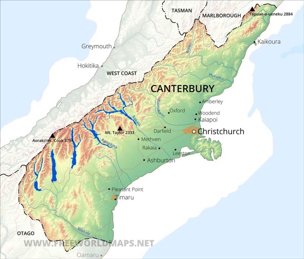
Canterbury
The Canterbury region is gigantic and covers a huge diversity of environments and things to do. Christchurch is the main city in the area weighing at about 450,000 people. All though we have seen many things in this region, it the area where we have probably toured the least. So you might be on your own in a few areas, mainly Mt. Arthur National Park. The western part of the region is big huge mountains and lakes. The east is the Canterbury plains and can be a bit dull and agricultural…but don’t despair, there is a lot to do on the East Coast as well. And….big bonus here….there are almost no sandflies in the Canterbury plains.
Kaikōura
In our estimation, Kaikōura is a must do on your trip here. It is the crayfish capital of New Zealand and, in fact, Kaikōura in Māori means “meal of crayfish.” The coast line is beautiful and the road winds between the wild ocean and some towering mountains. The town itself is quite small, but there are some nice places to stay.
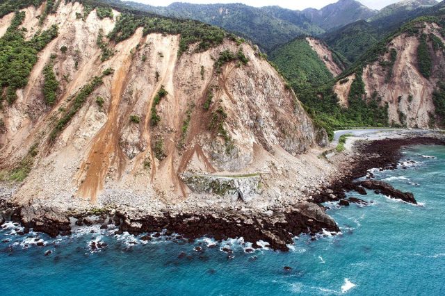
The drive down from Blenheim on Highway 1 is very scenic; it is very reminiscent of Highway 1 in California. There was a huge earthquake here in 2016 that lifted up the seabed over 2 meters. The entire town was isolated for months as landslides blocked the narrow road both on the north and south.
You can still see the scars of slips and the area where the seabed was lifted up. It’s impressive.
If you want to just get a good look at the area for a vantage point, head on up to the Kaikōra Lookout (GPS -42.417131, 173.691820)
Whale and Dolphin Watching
There is great whale watching here as the Kiakōura canyon creates a very deep water environment close to shore that attracts Sperm whales. The boats are super comfy and it is worth doing. The seas can be pretty rough here, so be prepared that your trip might get canceled. If it is busy season, best to book ahead: Whale Watch Kaikōra and Dolphin Encounter are the providers.
Bird Watching
One of the big draws to the areas for people interested in birds are the albatross. They are impressive. You will likely see lots of other birds as well as dolphins and maybe even a whale on the cruise. One company that runs tours is Albatross Encounters. There may be more.
Tramping
Kaikōra Penisula/Seal Colony: An easy hike that is a definite must do is the track along the shore of Kaikōra Peninsula in Kaikōura. If you want to see fur seals you have come to the right place. There is a huge seal colony here and the biggest hazard is not watching where you are going and tripping over one. Seriously, they are everywhere.
The hike starts at the car park at the end of the peninsula (GPS: -42.422902, 173.716257). There are a number of options that you can do; mostly out and backs. However, you can make a loop of it if you want (about 11 km). The description of the options are on this DOC webpage.
Mt. Fyffe Forest Walk: Fairly easy hike with a bit of a steep climb through a pretty forest setting. Just over 1 km and takes about 45 minutes to 1 hr. The car park is at the end of Mt. Fyffe Rd. (GPS: -42.335052, 173.640733).
Hinau Track: Easy hike of just under 1 km (45 minutes to 1 hr) through large Hinau trees.. The car park is at the end of Chapmans Rd. (GPS: -42.335052, 173.640733).
There are some really challenging multi-day treks in the area, but at the minimum they are rated as advanced tramping. So if you want to do something nutty, just ping me.
Biking
There are some great biking opportunities in Kaikōra. This webpage gives you a good overview.
The Kaikōrua Cycling Trail (48 km): The full trail is ridable for most levels of experience with some intermediate sections. It takes about 4 hrs to complete the full loop at a reasonable pace. You can do smaller sections of the trail as well. It is a mix of paved and gravel. Here is a good map and description for you.
The Whale Trail: The Whale Trail is the newest addition to the Great Rides and eventually will allow you to ride from Picton to Kaikōura. There are segments that have been completed (as of May 2025). A description can be found at the Whale Trail Website.
Christchurch
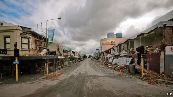
We aren’t huge city people and haven’t spent that much time in Christchurch itself. The city was destroyed by a huge earthquake in 2011 and now has been mostly rebuilt. Some areas were so devestated they basically tore everything down and made it into a park.
Overall it is a pleasant city, but I would describe it as pretty utilitarian. I am sure some local Christchurch people would take exception to my characterization, but there you have it.
Although we have not done it, the one place of note is the International Antarctic Centre which is supposed to be quite nice. Some friends of ours did it and really enjoyed it.
But don’t get too down on it, it’s a great jumping off point to some other amazing places and it has a major airport.
Banks Peninsula
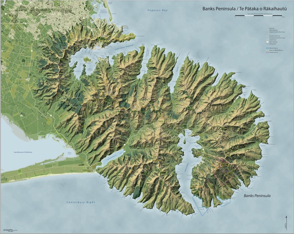
Just about 45 minutes outside of Christchurch is the Banks Peninsula. According to Google’s AI overview:
“it is two extinct volcanoes that formed an island that eventually connected to the mainland. Volcanic activity began between 10 and 15 million years ago, resulting in the formation of lava and ash cones. Over time, erosion, windblown loess, and glacial activity shaped the peninsula’s valleys, coastal cliffs, and indented bays. The peninsula was initially an island, but sediments from the Southern Alps eventually connecting it to the mainland.”
There are some great things to do on the Peninsula. The main town is Lyttleton, which is mostly a port city that services Christchurch. You can drive around the coastline there to Diamond Harbor. There are heaps of vacation homes out this way and it is quite beautiful once you are away from the port.
Akaroa
We spent time in Akaroa on the Southern end of the Peninsula. It is about a 1.5 hr drive to get there from the Christchurch CBD and is a cool little town with a French flair. Why French you ask?
“In August 1838 Jean François Langlois, captain of the French whaler Cachalot, ‘bought’ Banks Peninsula from Kāi Tahu for 40 pounds in one of a number of such purchases. In November 1839, what became known as the Nanto-Bordelaise Company was formed with the goal of establishing a settlement at Akaroa as the nucleus for a French colony in southern New Zealand (Te Waipounamu) that would be linked with a penal colony in the Chatham Islands.”
It is a tourist town, but definitely worth a stop. There are heaps of restaurants in town to try out. We had lunch at Tini Gin Bar Eatery. The food was decent, but the views were awesome. We also had dinner at Aihe, which was far more on the fine dining side of things; the food was quite good. Some friends of ours ate at Caldera Vineyard Estate and said it was the best meal that had in New Zealand.
If you want to work off that fish and chips you had for lunch, there is a great tramp right near town. Paddle boarding, kayaking and wild life tours are also popular activities with plenty of places to rent equipment.
Childeren’s Bay Farm Walkway (GPS: -43.797592, 172.964956): Right near town, this is a fun little tramp of about 5 to 6 km around a peninsula. There are some fantastic views of the harbor and surrounding hills, but what makes it kind of fun is that there are a bunch of animal sculptures scattered around the walk.

Misty Peaks Reserve Track (4 km): This is an out and back hike at the top of the mountains around Akaroa. Amazing views. A trail description can be found here.
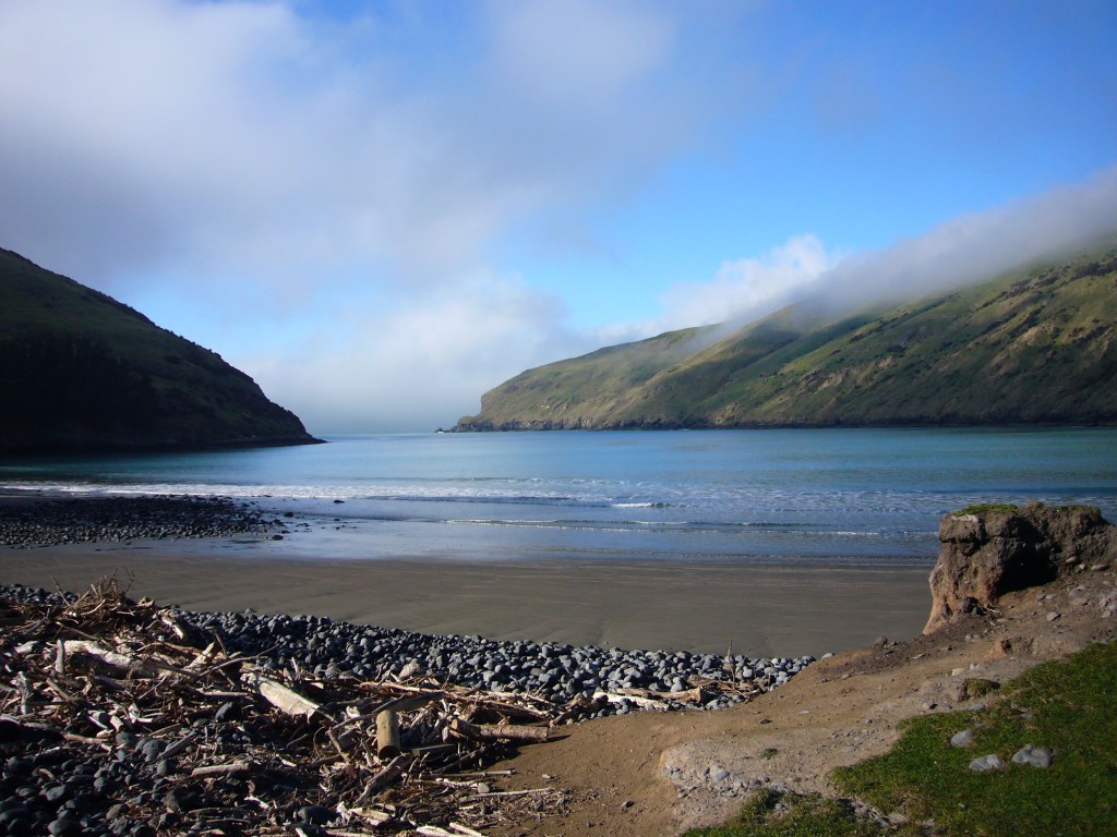
Flea Bay: Flea Bay is about an hour drive out of Akaroa and is worth a visit. There is a company that runs kayak and nature tours out there from Akaroa. It is a great place to go sea kayaking where you will see penguins, dolphins and fur seals in a pretty safe area for kayaking. The drive out is beautiful, if not a bit hair raising. I rode my bike up the road and it was crazy steep. They also have a blue penguin colony at the ranch so that you can see them up close.
Multi-Day Tramping:
There are a couple of options for multi-day tramping on the peninsula.
Banks Track: There is a 3-day hike that is run through a private company. We have not done this yet, but what we have seen and heard is that it is really spectacular and has some ability to make it a bit more swanky than the DOC huts.
DOC huts: There are a number of DOC and other land trust huts on the peninsula as well and a number of hikes that you can do from them. This website is probably the best overview of all the hiking you can do on the peninsula.
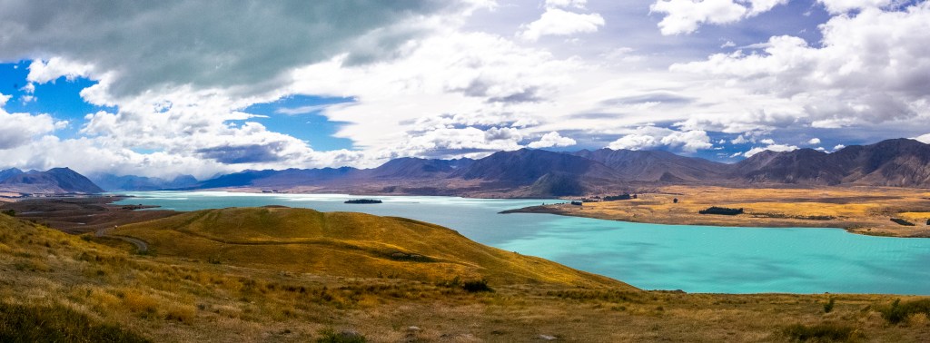
Lake Tekapo/Mt Aoraki
There is a lot to see and do in this area. It is also very popular and is on the main camper van/tourist must see route. Unless it is the middle of winter, do not plan on having the more popular places to yourself. That said, there is a reason that everyone goes here — it’s a must do.
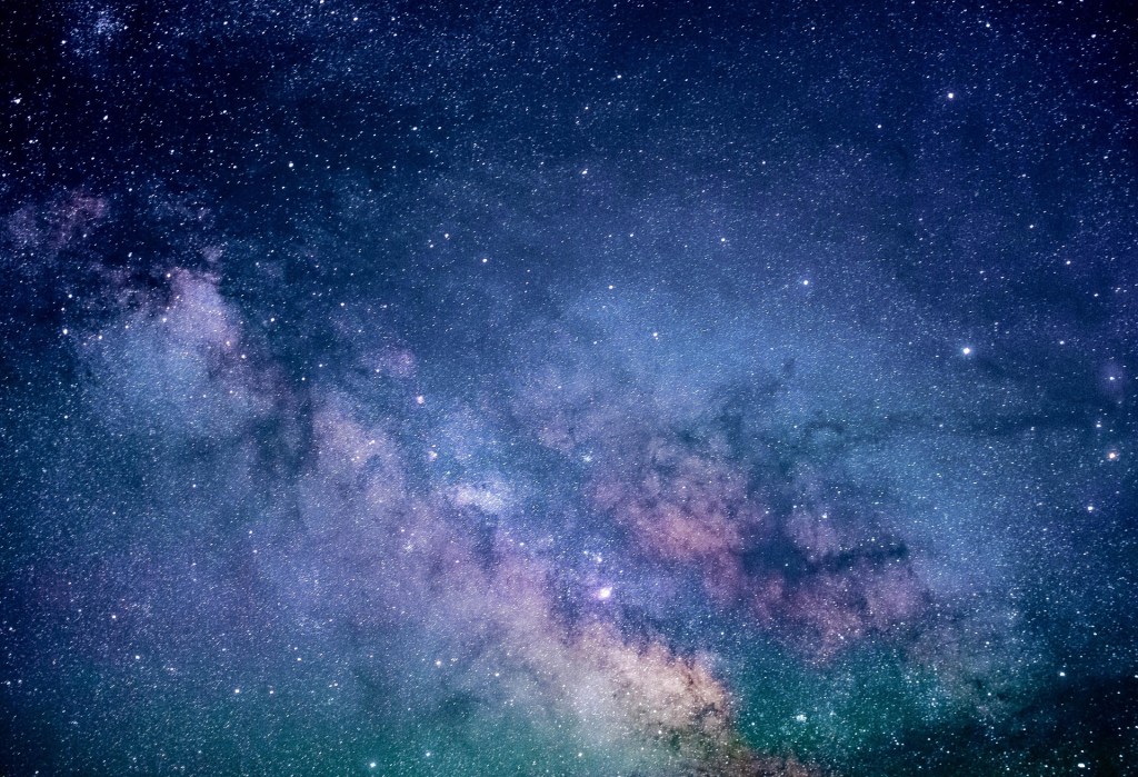
Lake Tekapo

The town of Lake Tekapo touts itself as the “Dark Sky Capital of the World”. It has turned into quite the little vacation town with some pretty fancy condos and time shares. There is a ski area near by so it has become the go to place for a lot of people in Christchurch.
Mt. John Walkway (9km): This is a must do tramp if you are staying at Lake Tekapo. It climbs up to the observatory at the top and makes a loop back around along the lake. It’s a bit of grunt up, but not too bad. The views are to die for.The DOC description can be found here.
Tekapo Springs: At the car park for the Mt. John Walkway is the Tekapo Springs, which is a commercial hot springs. We have not gone as it was a bit pricey ($27) and was over run by screaming kids the last time we were there. But, based on their website, it seems that they have non-screaming-kid options as well.
Flight Seeing: There is an airport in Tekapo that has flight seeing trips that go up and around Mt. Aoraki. If the weather is good, this is one of the 3 best places to organize a flight seeing trip. The view of the mountains, lakes and glaciers are truly stunning.
Dark Sky Project: The University of Canterbury Observatory at the top of the mountain hosts some of the darkest skies on the planet and thus some of the best star viewing you can find. It has become quite a thing and you can even soak in the hot springs while gazing at distant galaxies wondering if the string theory is a load of bunk. They even have a cafe that you can dine out. Everything you need know about designing your experience is here, but be warned it is not cheap.
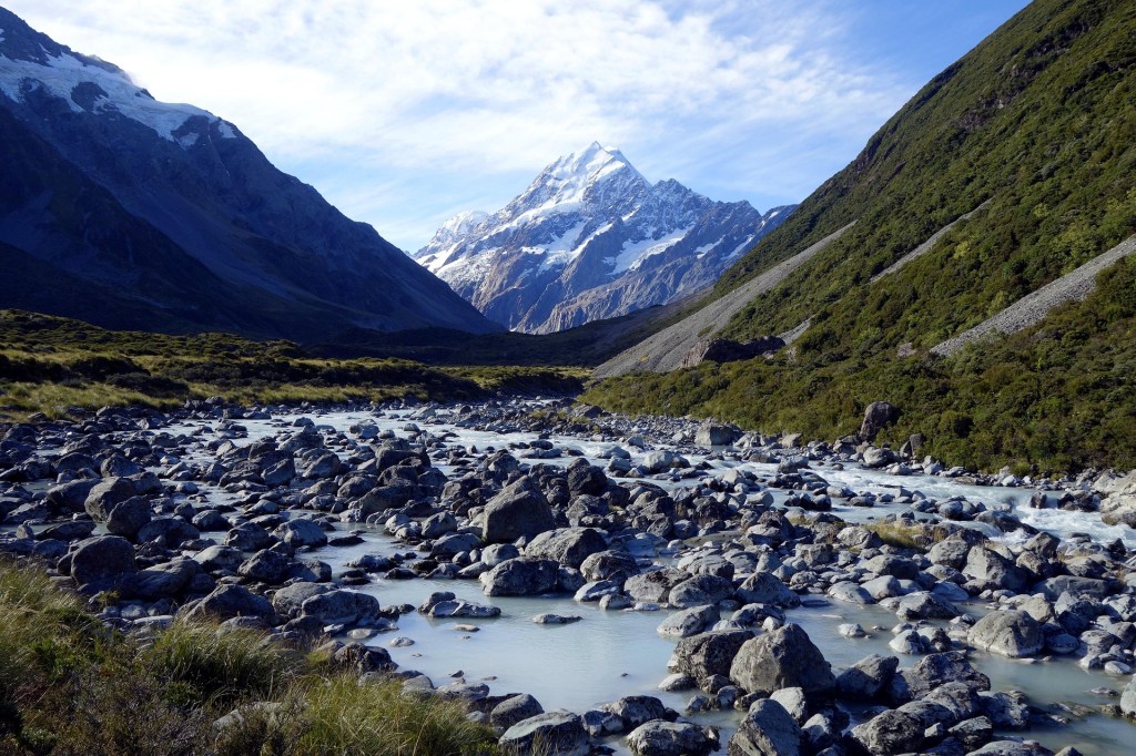
Aoraki/Mt. Cook National Park
When you drive from Lake Tekapo to the National Park, make sure you stop at the Lake Pukaki View Point (GPS -44.151152, 170.2072526) and marvel at the color of the water. On a clear day you will get a fantastic view of Aoraki. A bit further down the road is a salmon farm called Punatahu Visitor Center (GPS -44.189416, 170.139688) that sells all sorts of salmon stuff; it has a great view as well and is a very popular stop for Japanese tourists.
Another nice little stop on the way in or out of the park is the lavender farm (GPS -44.137180, 170.117471). If the fields are in bloom, it is stunning. They have some nice lavender products and the best was the lavender ice cream. Yummy.
The national park is huge, but most of it requires some pretty serious backcountry and mountaineering skills. You can drive to the end of the Lake Pukaki and reach the famous Hermitage Hotel along with a car park (GPS -43.719136, 170.093579) that services several trail heads. There is also a large campground that will most definitely be full of camper vans. We had lunch at the hotel and the view was crazy good, although it was a battle to find a place to sit down. I am sure the hotel is brutally expensive to stay at, but if you want a unique experience then it is probably a place that it might be worth blowing out the budget.
Hooker Valley Track (10 km): This is a tramp that is an absolutely must do. It is a 10 km out and back that takes you up to a glacial lake where you get a stunning view of Aoraki. It is not an overly hard hike, but does require some uphill. You are guaranteed to not have it to yourself, but do not let that put you off…it is definitely worth the effort. As of this writing (June 2025), the track is closed as one of the bridges is under repair.
Red Tarns Track (4 km): This is a lovely climb up to a view point that requires about 300m of climbing. From the main village, follow the track downhill from the public shelter to cross the bridge over Black Birch Stream and then climb steeply to the Red Tarns.
Kea Point Track (3.4 km): Relatively easy hike out to a great view point. DOC info here.
Mueller Hut Route (10.5 km): This “trail” leads to the very famous Mueller Hut and an absolutely stunning 360 degree view of the surrounding valleys, glaciers and mountains. It starts at the same car park as the Hooker Valley track. Be prepared though, this is a classic South Island hike and it goes straight up for 1000 meters over 5.2 km. It is steep and can be dangerous if it is at all icy. It does have a world-class view though. The DOC information is found here.
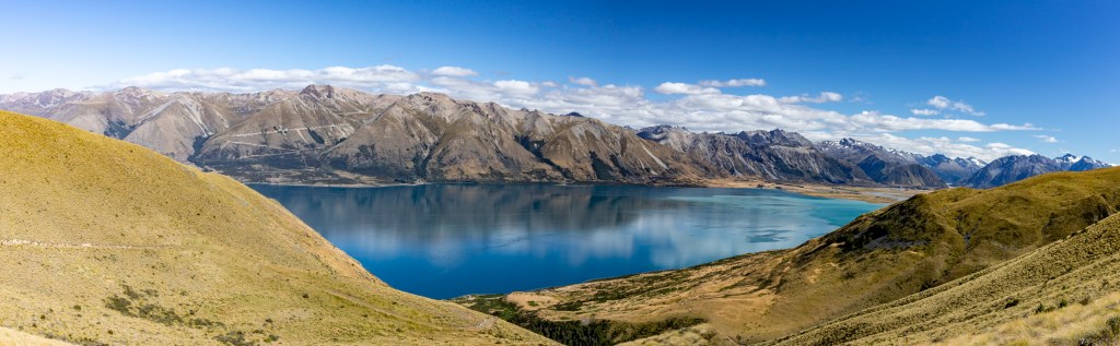
Twizel/Lake Ohau
Twizel is a cool little town just south of Lake Pulaski and deep in the heart of the McKenzie Country. There isn’t much there other than a 4 Square, some bike rental shops, a holiday park and a few restaurants. The Poppies Cafe was quite nice; worth a lunch stop. The Alps2Ocean cycle path (A2O) goes right through town. There are some nice Airbnb houses to rent in the area (although not cheap during peak season). If you are into fishing, there the famous Ohau canal here that hosts some of the largest trout and salmon on the planet with the world record brown trout coming in a whopping 44 lbs.
One day bike ride on A2O: You can rent a bike and get a shuttle from one of the bike shops in town and ride a section of the A2O trail. We did a section from Lake Pukaki back to Twizel. It was easy riding with great views and took about 2 1/2 hours. You could do a longer version and start from Mt. Cook Village. The bikes were not the best, but they worked.
Lake Ōhau Track (as long as 16 km): This track runs along the shore of Lake Ōhau and is an out and back. You could do the whole section and it would be 16 km. It is quite easy walking and is part of the A2O trail. If you are looking for a tramp with great views but is not too hard, this is a very nice one. You have a choice to start closer to Twizel or Lake Ōhau. The car park and trail head from the Twizel side are at GPS -44.285622, 169.94310 and from the Lake Ohau side at GPS -44.286035, 169.863320.
Climbing Ben Ōhau (10 km): If getting amazing views is your jam, then this hike is for you. Head out Glen Lyon Rd. from Twizel to get to the car park for the Greta trailhead (GPS -44.249603, 169.877903). The DOC write up is here. The trail climbs up through a valley before popping out onto the open slopes of Ben Ōhau. There is very little shade, so if it is a 30 degree summer day, bring lots of water…it is hot. The trail climbs pretty consistently up to saddle at about 1350 m. At the saddle head eastward up to the top of the peak at 1522 m. It is mostly a route and not really a trail, but easy enough to follow. The views at the top are stunning. You can turn it into a loop and continue along the Greta track which traverses the ridge and then loops back around down into the valley you started on. This makes for a 16 km trip total.
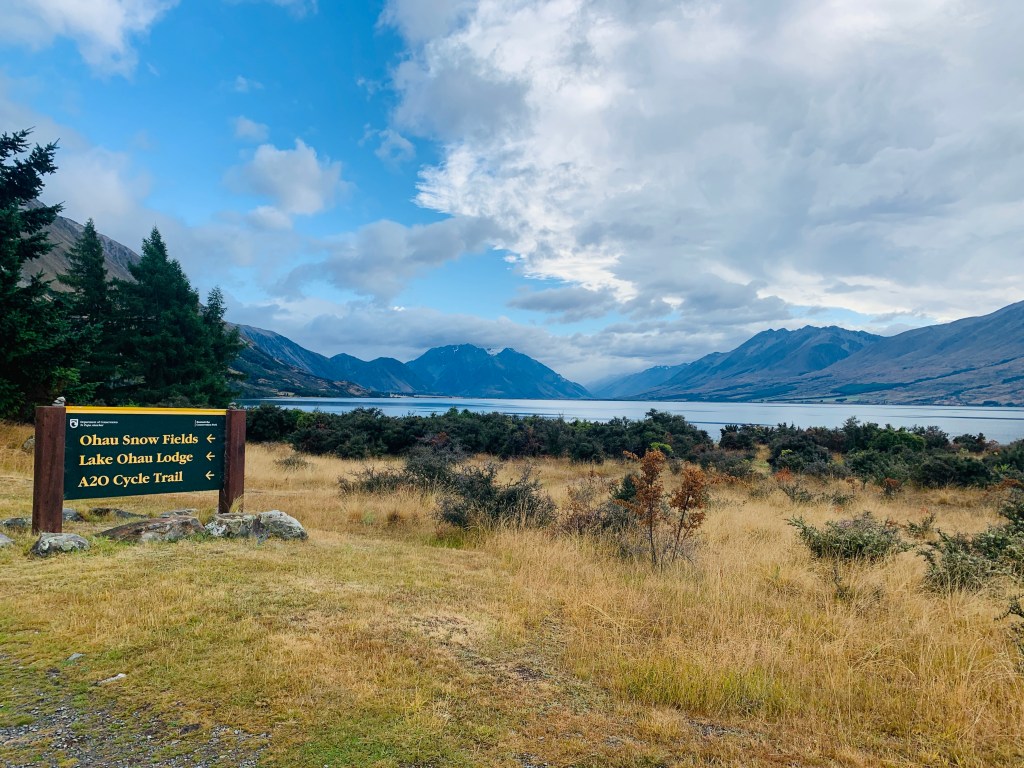
Up the road from Twizel is the small village of Lake Ōhau which has a campground and number of houses that you can rent. It is a popular summer hang out and there is even a small ski area there…although the road up to it gives me the hebbie-gebbies just looking at it. If you continue on past the village you will go by the Lake Ōhau Lodge which is a popular stop-over for people riding the A2O. Further past that you come to a gate and the end of the maintained road. It continues past the gate up the Hopkins Valley.
Hopkins Valley Track (as long as you want): This track follows along a 4×4 track. It is drivable if you know what you are doing, have a 4×4 with good clearance, are comfortable driving across a river and the weather has been good. It is also popular with mountain bikers. If neither of those appeal to you, it is a pleasant walk up the road from the car park (-44.093943, 169.845587). The views are pretty amazing. You can go a long way and it eventually leads you to a number of back country trails with huts.
Riding the A2O: The section of the A2O that goes by the Ōhau Lodge is considered one of the “big hills”. It’s a great section to ride and ultimately would take you all the way to Omarama. I rode it as an out and back for about 35 km total. It really isn’t that hard of a hill (mostly 3 to 5% grade) and views are wonderful. The official DOC name is the “Tarnbrae track” and it starts right by the Lodge. You could pick it up in a couple of other places, but that is the most straightforward.
Areas we have not explored
Hamner Springs
This is a famous hot springs area that has many developed hot springs to enjoy; the boast it as “New Zealands Largest Thermal Reserve and Water Park“. There is some great hiking in the area as well. We have yet to go. Stay tuned.
Arthur’s Pass National Park
This is a lovely area just east of Christchurch. There are some great lodges and tramps to do. We just have not done them. Some friends of ours took the TranZalpine Train from Christchurch up through he park and to the West Coast and loved it.

Let me know what you think!