
Ok, so my last post was probably the weakest of all time. Sorry about that. Just trying to get the blogging engine restarted. I did have a lot of things to talk about, but just couldn’t seem to get them out of my head and into words. There you have it. We all have to put out a stinker now and again.
I remember when I was in grad school and I gave a talk at a conference in Vancouver B.C. As I was talking, I could see the look of pain in the faces of the people in the audience. To put it mildly, it was a disaster of a talk. A first-degree stinker. After I finished I thought to myself, “at least I have now given the worst talk of my life and it is behind me — they only get better from here.” Let’s hope that is true for the blogs as well.

A friend of ours, who had come to visit and seen all the stuff I had been building on the ranch, sent me an interesting article that really resonated with me. I loved the title: “Making things with your hands in a world that doesn’t need you to.” When I look at my greenhouse, garden beds, chicken coop, retaining wall, gate, and other things I have built, I feel a sense of pride that I built them. I could have paid someone to do it and they would have been better constructed, but so much gets lost in that process. There is something about making and fixing things that connects you to the world, the real world. It creates a level of humility that deploying wealth can disconnect you from. I also listened to an interesting podcast from Ezra Klein that featured Stewart Brand. Very interesting guy with a very long history in Silicon Valley. What I loved was his focus on the importance on maintenance as a way of life and connection—a virtue. Anyway, worth a listen and I hope when I am 89 I can be as sharp as he is.
Ok, on to the main event—the Travers-Sabine tramp.
I had such a great time last year tramping across New Zealand, I really wanted to get back out and do some more. Just a short drive away is Nelson Lakes National Park which has a number of big multi-day hikes. The Travers-Sabine is one of those. I kind of wanted to do it solo, but decided that if Bev was available, it would be great to have him along. He said yes. It is never hard to get him to come along on a tramping adventure … biking, that’s another story.
I found a good weather window and what looked to be a time when the huts weren’t going to be too full. We got our food in order and the plan set.

The plan was to take a water taxi to the end of Lake Rotoiti and start the hike there. It was going to be 6 days and 5 nights. On paper there were two long days, but overall it didn’t look too bad as the second long day was downhill.
I had noticed that there was no one in the Blue Lake Hut, so we planned a modified circuit by spending the night in that hut as Blue Lake area was supposed to be beautiful. The longest day was from Blue Lake Hut to Sabine Hut which was about 25 km but was downhill. Easy Peasy. Right?
We also varied the normal route and were going to cut up to Angelus Hut for the last night, weather permitting.
Day 1: Lake Rotoiti to Upper Travers Hut
23 km, 1000 m elevation gain
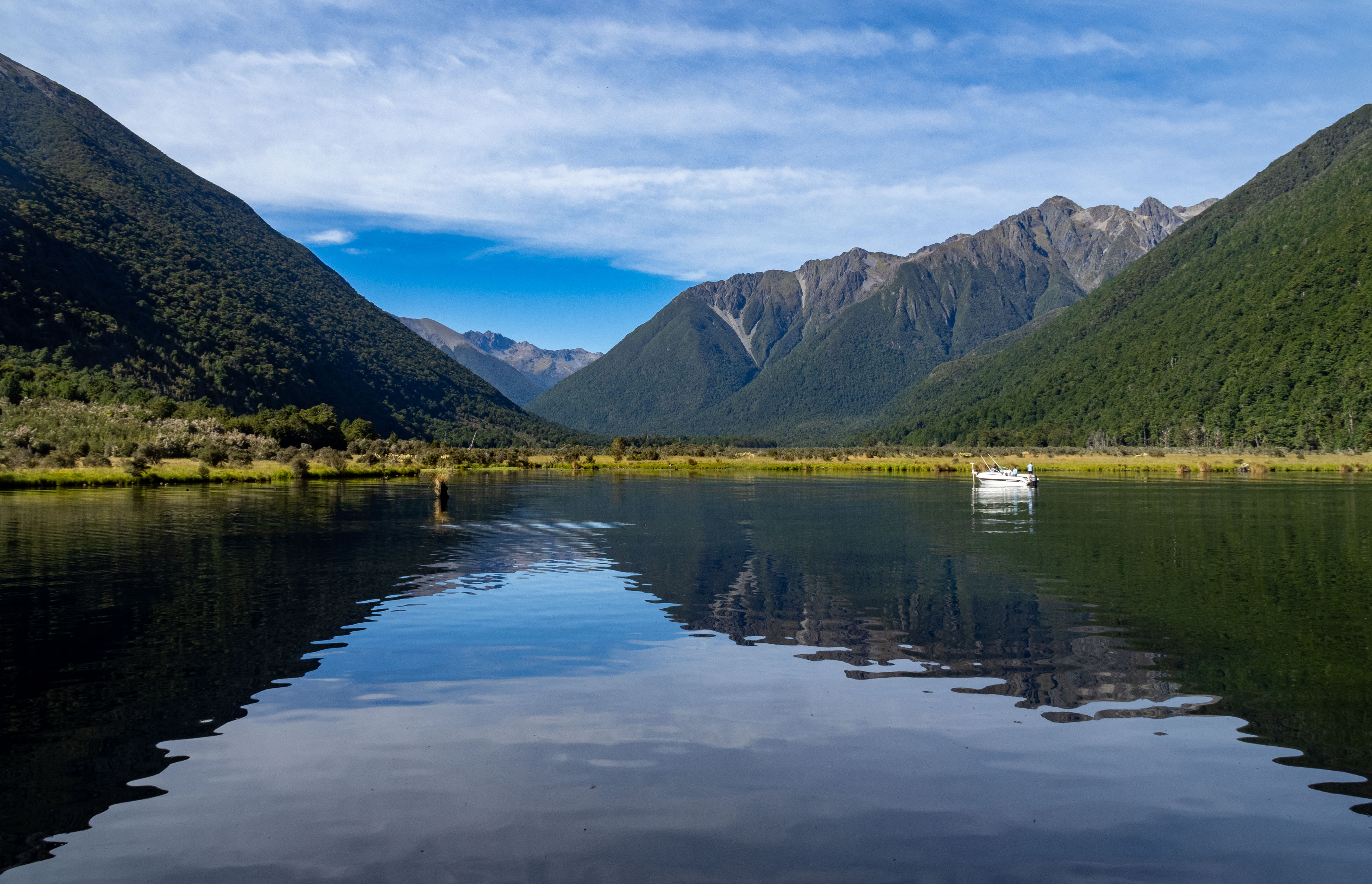
I met Bev at the Mount Roberts car park where we would leave the car. Bee, Emma, and Ethan came along to do a day hike around the lake, so they drove us down to the water taxi. That made the shuttle logistics way easier. We got on the water taxi with a couple of other people and headed across the lake. It was shaping up to be a cracker day!

It was a later start than I normally like because of the drive up from Māpua, the vehicle shuttle and the water taxi, but there you have it. We said “adios” to the rest of the crew and headed up the trail toward the Lakehead Hut. It was clear from the number of people at the hut that the Upper Travers hut was unlikely to be empty. I can never figure out why the DOC website shows a hut as nearly empty and then you show up and it is chocker block full.
On paper the hike didn’t look too bad, although it was a bit long. It had a pretty gentle climb up to the John Tait Hut and then a shorter, steeper grunt up to the Upper Travers Hut. The walk through the valley was lovely with the beautiful green color of the Travers River, the golden grasses in the meadows and the towering peaks around us.


But this is New Zealand. Easy on paper is rarely that … especially when it involves mashing through a beech forest. Although the trail wasn’t terrible there were a lot of steep climbs up rocky buttresses, over downed trees and, of course, root ladders. There had been a few huge storms in the area over the last couple of months, so the trail was probably harder than normal with all the washouts and downed trees. The section on the other side of the Travers River has been described in one hiking review as “diabolical” because of all the obstacles created by the storms.


We were moving along at an ok pace—not fast, not slow—and feeling ok despite our lack of sufficient training. My ankle with the torn ligaments had been bothering me before the trip so I was hoping it would settle down and feel ok, but I could tell it was not where it should be.
We passed the John Tait hut and it was packed. It was already 3 pm and we still had the big climb to go. After about 6 hrs of hiking, we stopped for a break. I think we were both feeling a bit knackered and the day was starting to drag on and on and on.
After 8 and 1/2 hours of tramping we made it to the hut. The location was absolutely stunning. It was already almost 6 pm and the hut was busy. We found some bunks and unpacked. I noticed my Katadyne water bottle had fallen out. Ugh. I was faced with the terrible choice of losing the bottle or hiking back to get it. Neither was a good option. I was hoping someone would show up that had picked it up. The Indian dude from Australia that we had seen on trail did show up, said he had seen it but didn’t pick it up. Arg! He said he thought it was trash. Even more of an ARG!

I decided I was too tired that night, so I would dash down in the morning and try and find it. We ate our freeze dried salmon dinner and both commented on what an epic, tiring day that was. Just then Bev said “There’s some people coming up the trail!” I ran out to see if they had my water bottle and they did. Yeah! A good end to a long day.
Day 2: Upper Travers Hut to West Sabine Hut
9 km, 600 m elevation gain.
A short day, right? The DOC brochure states the expected hiking time is 6 to 9 hrs. What?! For 9 km? Seemed off to us.

The hike started from the hut and climbed up a steep cirque wall about 400 meter to Travers Pass—the high point of the trip. Although steep, the climb up wasn’t bad at all. It was an awesome day with very little wind which is a rarity in this part of the world. Nelson Lakes National Park is known for some pretty crazy strong winds.

A young family passed us on the way up. I told them they should carry my pack; they told me I was old and needed a helicopter. Well, they didn’t actually say that, but I bet they were thinking it. It is very common to see whole families out tramping these multi-day hikes. It is just part of the kiwi DNA.

We pulled out some food and sat there just enjoying the day. The Indian dude that hadn’t picked up my water bottle showed up and we chatted with him. We had made pretty good time up this point and it was all down hill from here … 1000 meters of very steep downhill. My ankle was not looking forward to that.


The first section required navigating over pretty big boulders on a steep slope. It took a lot of concentration and pole work to make sure you didn’t go hurtling down the mountain. We picked our way slowly down and finally got to the tree line. I thought, “oh good, it should ease up now”, but a niggly thought went through my mind “ack, it’s the beech forest.”
The gradient didn’t really let up, but now the boulders were replaced by root ladders. It was slow going and really hard work. After about 700 meters of descending we reached the river where the gradient eased up. This, however, did not make the trail all that much easier. We had one fairly flat stretch that lasted about a kilometer that required an insane amount of effort. Bev turned around at one point and said “this is crazy hard work … and it’s flat.” We were barely able to go 1 km/hr. My ankle was killing me and I started to really worry about the sanity of being out there on a suspect limb.
We got to the hut at around 3 pm and it was already pretty full. It took us 7 hours to go 9 km … very humbling. We got our spaces on the upper bunk and headed down to the river to wash off a bit. The water was cold but felt great to splash the grime off. The sandflies were ferocious though, so it was not a leisurely bath.

The West Sabine hut is an older hut that sleeps 30 people and that night it was going to be full. Everyone was spread out on one of two platforms, smashed in next to each other. The cooking and eating areas were way too small for 30 people, so it required some coordination to make sure everyone got what they needed.
Like the Upper Travers Hut, this hut is located on the TA (Te Araroa) trail which is a through hike that runs the length of New Zealand. It is like the Pacific Crest and Appalachian trails in the US. It takes 3 to 4 months to complete. It has become quite popular and puts a lot of pressure on the huts along the trail.
Despite having 30 people smashed into this little space, everyone was great in terms of settling down and going to bed. No crinkly bag ladies here. And pretty much everyone was quiet as a mouse until morning … except for me probably … I am sure I snored at some point. Doh!
Day 3: West Sabine Hut to Blue Lake HUt
8 km, 500 m elevation gain.
Today was truly the easy day on the trip. A lot of people spend two nights at the West Sabine hut and do Blue Lake as a day hike. It is an amazing area so I thought it would be great to have an easier day and get a chance to check out Blue Lake and Lake Constance.

Bev was happy when I told him there was no big hurry in the morning and that we could lollygag around until 9 am. He found this far preferable to my usual 6 am torturefest. We had some coffee, leisurely packed up, and then headed out for a hopefully easy day of tramping. My ankle was very sore and my quads were feeling the 1000 meters of tough descending from the day before.
The trail follows along the Sabine River climbing gently toward Blue Lake. The river is staggeringly beautiful. There were the usual up and down scrambles through the beech forest, but not too bad. You could see where the trail had been washed out and was rerouted in many of the side streams. A lot of times, you were required to boulder bash up the creek until you found a place to get to the other bank. Thankfully it had been dry, so there was no issue with any of the crossings.


Up until this point the weather had been perfect, but there was a storm forecasted for the following day. As we worked our way up the trail, you could see the precursor of the storm starting to build behind us.
We got to Blue Lake Hut around 1 pm and both were relieved that the hike hadn’t been too hard. My body definitely needed a bit of an easier day. There were a few other people there, but our hopes remained high for having a less crowded hut.
I walked out to Blue Lake to take some pics. There is a sign there telling you all about it. Evidently, it is the clearest known fresh water in the world. You are not allowed to touch the water for fear of losing this distinction.
On one end it was more Green Lake than Blue Lake, but the emerald color was pretty amazing. They weren’t kidding about the clarity of the water. In places it was probably 10 meters deep, but it looked like you could touch the bottom….not that I did since you aren’t supposed to touch the water 🙂


I walked around the lake to the other side and then the blue colors started to pop. It isn’t a huge lake, but I can see why it is famous for its beauty.

We hung out at the hut for a while as more and more people kept showing up. Doh, so much for an empty hut. We decided to take the relatively short hike up to get a view of Lake Constance. It was about 200 meters of climbing to get to the view point, so we headed out to take a wee peek. The trail was pretty straightforward, but I could tell we were both pretty tired. As we gained elevation, we got a great view point back toward Blue Lake. Wowzaa.

We couldn’t quite tell where the look out was and there was a fork in the trail and we headed up. I saw someone coming down the saddle and realized that we were on the trail that went over a brutal pass, so we found a good view point and just hung out there taking in the view.
After a bit, the person we had seen descending the skree slope, a Canadian woman from Ottawa, showed up. We chatted and found out all the crazy tramping she had been doing. She was doing the TA but starting in Bluff in the south and working north. She was crazy fit, to say the least.

We headed back to the hut and it was now nearly full. Ugh. We had dinner and hung out. The TA crowd is very different than what you find in the huts that are not on the TA. A lot of the people have been hiking together off and on for months. Most of them are quite young, from other countries and looking for an experience. They spend a lot of time talking about the TA and things that have happened on the TA, but mostly amongst themselves. It’s not an over-welcoming vibe for those of us just out on a tramp.
A group of them showed up around 6:30 pm and were planning on just staying in the hut for free, but were disappointed when they found out there was a hut warden there. I think what has gotten under the skin of a lot of kiwis and myself is this sense of entitlement to the resources and free-loading on the system. It gives this crowd a bad name and has certainly put a burden on a hut system that is such a treasure.
Of course, some group showed up at 9 pm and then spent the next hour cooking dinner, stretching, crinkling bags, and making a racket. Ugh. So much for an empty hut.
Day 4: Blue Lake HUt to Sabine Hut
26 km, 250 m elevation gain.
It rained really hard all night long. MSSR — Milford Sound Sheets of Rain type. It was not looking like an overly pleasant day for tramping, but the forecast was calling for it to let up as the day progressed. Again, on paper the day didn’t look too bad. Long, but all downhill with a few bumps along the way.

We packed up our stuff and got going pretty early to make sure we had lots of day to work with. It was raining pretty hard at the start as we worked our way down from Blue Lake Hut. All of the dry creek beds that we had traversed the day before we now raging streams that needed to be crossed with care. My ankle was absolutely killing me and I did not trust it at all whenever I had to make leaps over boulders. My motto is always “don’t make a mistake.” As much as I love riding in helicopters, I really did not want to be airlifted out of the back country. So we plodded along being very careful.

We got to the West Sabine hut and decided to have an early lunch and get out of the weather for a quick break. The super fit Canadian woman caught up to us and we chatted. It took us an hour longer than it did her. We had the old guy pace, she had the super fit TA pace. She was planning to stay at the Sabine hut as well, so we figured we would see her that evening.
Whenever I think “ah, the trail will ease up now,” I know that I have just set myself up for a sufferfest. Bev, who had hiked this section 20 years ago, claimed it was easy, so maybe this time I was right. We headed out from our lunch stop and the good news was that the weather was clearing … not that you could see much because the trail worked its way through very dense beech forest.
It was much harder than I expected with a ton of downed trees to navigate over and around. This was in addition to the usual root ladders, boulder scrambles, bogs, and creek crossings that are just par for the course.
Our pace was way slower than I expected and I could feel the effects of the effort. Between the weather and my ankle, I started to doubt whether we should attempt the climb to Angelus Hut.
“No mistakes” kept going through my head.

Despite being “downhill”, there was a lot of up and down along the bank of the river. One thing about this trails is that there is rarely a step that you don’t have to think about or concentrate on. It wears you down mentally as well as physically.


We made it to the base of the valley where it seemed like things should open up. However, there was a steep canyon that needed to be avoided. This required a steep 150 meter climb up a boulder-filled, root ladder-ridden “cliff” and then back down again. Ugh. I was getting very tired and my body was telling me to stop. I mentioned to Bev that I thought that we should alter our plans for tomorrow and not go up the steep route. I think he was relieved to hear that.
The last couple of kilometers would have normally been easy, but mentally I was fried, my body was sore and I was ready to get there. At last we made it.
It was 2 km longer than DOC claimed and took us 10 and 1/2 hours of pretty steady hiking. And this was all downhill. Whew. I have mentioned this before, but it is hard to communicate how difficult tramping through the beech forest can be.

We piled into the hut, unloaded our stuff, got into some clean clothes and both laid down and took a nap. I was exhausted.
After our nap, I was out in the main area making some tea and just trying to recover. The sandflies were thick as thieves outside the hut. It is times like this that you don’t mind putting up with some snoring and crinkly bags; the thought of being in a tent surrounded by billions of sandflies is not a good one.
As a side note, the fit Canadian woman was not at the hut. She must have pushed on to Angelus Hut. Like I said, she was crazy fit.
I was chatting with another hiker who told me a group of them was getting a water taxi out via Lake Rotoroa the next morning and we could probably join if we wanted. I hadn’t really considered this option before, but based on how I felt and how the weather looked this sounded surprisingly good. Bev came out from his nap and I brought up the various options for the next day. When I said we could always take the water taxi out, the total delay between when the words left my mouth and when Bev said “YES!!!” was exactly 0.0032 milliseconds.
We had just enough cell signal that I was able to arrange for Susanne to come and meet us the following morning at the dock at Lake Rotoroa and shuttle us back to the Ute. Yeah! I hate bailing on the plan, but there are times you just have to do it. We had a great meal and I slept well that night.
Day 5:Water Taxi Out
0 km, 0 m elevation gain.

The taxi came and picked us up at 9:30 am. I think both Bev and I were glad to bail on the rest of the trip. The weather looked bad up high and the thought of navigating over more root ladders was not overly appealing.

Ian, the dude who had given me the idea for the water taxi, was heading to Abel Tasman next. I offered to give him a ride to Motueka. He was grateful as it saved him a long boring bus ride. He was from Ireland and on a long trip around New Zealand. I think the tramping was way harder than he expected as well and was looking for a much easier time at Abel Tasman.
Susanne drove the 2 hours up to get us at the boat dock. What a champ! Hero of the trip! She got out of the car to great us, got swarmed by sandflies and promptly jumped back in. Maybe we weren’t that important after all. We picked up the Ute and drove back home. I dropped Ian off in Motueka and was glad to be home safe and sound.
Final thoughts:
It was a good trip, but not a great one. Both Bev and I agreed that Rees-Dart was much better. Although there were some amazing views, the vast majority of this tramp is through the dense forest with little or no view. I like the forest but after 10.5 hours it would be nice to see something other than a mud bog or root ladder. I think this circuit is over-rated.
The TA crowd wasn’t all the enjoyable to hang out with. I’ll probably avoid TA routes in the future.
I am always humbled by how hard the hiking is here.
My ankle is not good. Last year, I managed it well, but on this hike it was on my mind constantly. It is the first time I really felt like, “maybe it’s not safe for me right now.” That bummed me out. I felt old. I also knew I was going to have to finally admit, after 2 years, that I better go get it looked at. Sigh.
I am grateful to have such a good tramping partner. We both see things similarly, have executed great judgment in times of decision and are always willing to make sure that other is doing well. It is important to have a partner you trust when you are in the rugged back country.

Leave a Reply